Snow and Ice in the UK
Snow and ice conditions in the UK's mountains are governed by two major factors:
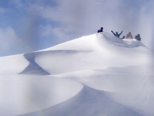
1) Wind: In winter, in Scotland, there is usually a lot of wind. Only 1 in 5 days has wind of less than 20 mph on the Cairngorm Plateau. Wind has a major effect on snow. Firstly it is constantly shifting the fallen snow from the exposed windward slopes on to the lee slopes, this creates windslab, the cause of the most common avalanches in Scotland (but more of that later). Secondly, if it is windy (over 20mph) and snow is airborne either when it is falling or when it is being moved the constant collisions mean that the snow crystals get smashed up meaning that when they do land they are less able to bond with one another. Poorly bonded snowflakes create an unstable layer in the snowpack making it more likely to avalanche.
2) Temperature: Unlike the higher ranges of the world the temperature often fluctuates to either side of the freezing point of water in the UK. This means that the snow often consolidates differently to how it does in many other places. The snowpack is safest after it has been through a few melt-freeze cycles making it more consolidated.
 The Life of Snow
To look at the life of snow I think that it is useful to look at how snow behaves in different conditions. First, let's look at how snow behaves in the 'perfect' conditions that we don't usually get in Scotland.
Still conditions and constantly below freezing
When snow falls on a beautiful, still day the flakes land on the ground and all the little feathery bits on the end of the flakes interlock and can create a nice (fairly) stable layer (for the time being and so long as there isn't too much of it). The snow then goes through dry snow metamorphism (also called rounding). During this period point release, dry snow avalanches and slough's are possible as the bonds between the feathers of snow are weakened. If the layer gets through this period without avalanching then sintering will have occurred. Sintering creates a very stable layer of what is known as firn snow or neve. The process of dry snow metamorphism and sintering only occurs if the air temperature stays below 0 degrees C. The closer to 0 degrees it is the faster it happens. The process stops at temperatures of -40 degrees C.
When the Wind Blows
In Scotland the conditions that we usually get are windy with temperature fluctuation on either side of the freezing point of water. When wind blows on a hill side it picks up the snow and carries it with it. The wind starts to pick up snow in an appreicable amount at 20 MPH but the stronger the wind the more snow it can carry. If you imagine the wind rushing up a slope it is getting stronger and stronger as it reaches the top as it is getting more and more compressed between the land and the upper atmosphere. As it does this it picks up more and more snow. When the wind then passes over the top of the hill it suddenly has lots more room and slows right down, this means that it dumps all that snow that it was carrying onto the leeward slope of the hill. This dumped snow is made up of broken crystals that look like rods (you can scc this if you look at them under a magnifying glass). The layer formed by blown wind is called windslab and it is inherently unstable. Much of what we walk on in Scotland is windslab or was deposited as windslab. Windslab layers are stabilised by both dry snow metamorphism and Melt - Freeze metamorphism.
Avalanche
Geographical and snowpack risk factors in avalanche
Avalanche occurs when the force holding a layer of snow to the layer below it is less than the force of gravity acting on the weight of the snow and unsuspecting walker or skier who it on it at the time. Factors that dictate where an avalanche will happen are many and can vary widely within meters of each other. This is due to the shape of the land sometimes resulting in isolated pockets of windslab being deposited when the rest of the slope may be relatively windslab free. The most important geographical and environmental factors are
Steepness of slope. Shallow angled slopes avalanche less than steeper slopes and very steep slopes tend not to accumulate snow in quantities large enough to produce a dangerous avalanche. Most avalanches occur on slopes between 30 and 45 degrees though they can occur on slopes that are as little as 20 degrees.
Aspect of slope. As stated earlier windslab forms on the leeward slope of a hill, however there is a bit more to it than that as we have to figure in terrain traps. Imagine a hill side in summer, it is generally not a smooth uniform slope. It is a knarly lump with some bits steep and some shallow and then there are bumps and crags and hollows and rivers running down it. Even on a windward slope you can get pockets of windslab. If your slope has streem running down it then there may be a leeward aspect to your ostensibly windward slope.
Stability of the snow pack. This is the biggie. What makes a stable snow pack? Basically snow packs are made of different layers that are deposited at different times throughout the winter. The stability of the snow pack depends on how well these layers are bonded together. Over time and with melt freeze metamorphism many layers will be indistinguishable from each other but until that time there could be a danger. So if conformity between layers makes for a stable snow pack what can we identify that makes a dangerous one? Sometimes snow and ice structures between layers can help to 'lubricate' them increasing the danger of avalanche. Layers of Graupel, Surface Hoar and Depth Hoar (AKA Facets) are bad news. Soft layers under hard layers near the surface are also particularly dodgy but really any distinct layers, no matter how thin if buried, could be a cause for concern.
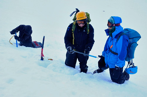
We can do various snow stability tests as we go on our journey across a slope, for example, snow pits, snowball test, trench/shovel shear test etc. However, a test that indicates stable conditions is only valid to the specific location of the test and the time it was done; doing the exact same test even just a few meters away could give a different result due to the unconformity of the slope and geology below the snowpack. Therefore it is very important not to rely on these alone, but to build up a picture by looking at the history of conditions and weather in that area over the season, and to make general observations throughout the day.
When digging your pits the main things you are looking at are 1) The distinguisable layers of the snow and if there are big sudden changes in the hardness of the snow / ice. 2) How the size of the different layers changes throughout your journey across the slope (is the top windslab layer getting bigger or smaller?) 3) If you do a shear test you are looking at the shear surface, are there facets or graupal, is it lubricated in another way, is it very smooth?
Danger times
There are times when there is an increased risk of avalanche
- Very cold for long periods of time. Neither melt - freeze or dry snow metamorphism will be happening
- Cold air temperature on a shallow snow pack. This can create a large temperature gradient which can lead to the formation of Depth Hoar. The snow pack is usually shallow early in the season.
- Rising temperatures. The snow is getting wetter and heavier, the melt water can also act as a lubricant between distinct layers within the snow pack.
- Rising temperature during snow fall. Snow that starts of warm and wet and ends up getting colder and dryer will bond better with the layer below than a snow fall that starts off cold and dry and ends up warm and wet.
- Heavy rain. This will make the snow heavier and help to lubricate it.
- During and after heavy snowfall (Heavy snowfall being approximately 2 cm per hour).
How to stay safe
Most of your avalanche safety work should take place in your route planning. With both weather forecasts and avalanche forecasts now available for many areas of Scotland it should be possible to plan a day out where ever you are that will stay safe by sticking to ridges and windward slopes above the snow line. Always be open to changing your route choice during the day if your original plan proves more susceptible to avalanche than first thought. It is also, however, sometimes possible to venture on to slopes that forecasts would suggest are suspect and to do so in relative safety. This brings with it increased risk and should not be done lightly, it is very much the case that a little knowlege can be very dangerous. Don’t be fooled by the look of slopes alone; one of the worst avalanche events in the UK took place in a town in Sussex, 1836, when a huge avalanche came down a relatively short slope above Lewes killing 8 people! Winter skills and avalanche awareness courses will help, as will years of experience and taking an interest in the snow pack whenever you are out.
Snow structures and wind direction
There are a number of snow and ice structures that you can look out for that will give indications of wind direction and activity. It is useful to know which way the wind has been blowing as if snow has been moved from where you are it is an indication of where it has been moved to.
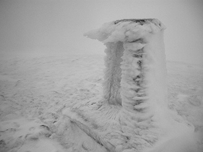
Rime.
Rime is ice that has frozen onto an object. Rather counter intuitively it grows from the object in to the wind. This is because the wind contains water droplets and when they hit the fence or trig point or rock the cooling freezes the water.
Sastrugi
Sastrugi can be tiny from a few centermetres to over a meter high. If the wind has been blowing from the south then the sastrugi will be formed in a North / South direction with a shallow slope on the south side and a steeper slope on the north.
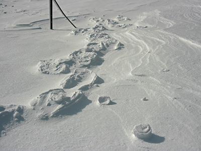
Raised footprints
Raised footprints indicate that there was a lot of snow here but it has now gone. Where it has gone to is anyone's guess. When there was snow there someone (or an animal if they are animal prints) walked along and compacted the snow beneath their foot into a lump of ice. Then the wind came along and moved the snow save for the compacted ice block with a footprint on top.
 |  |  |